
BGS and partners developed robust quantitative groundwater maps for Africa that highlight those areas more likely to be resilient to climate change and where sufficient groundwater resources may be available to help adaptation.
The maps were the first produced for Africa and were underpinned by dedicated case studies, and systematic data and literature reviews.
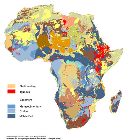

Figure 1 The geological base map used to develop the aquifer maps. UNESCO 1:5 million geology used within the USGS superficial geology data. BGS © UKRI.
Developing the maps
Understanding and characterising the resilience of African groundwater to climate change requires an understanding of the spatial distribution of groundwater storage, aquifer permeability and the annual rate of recharge.
In groundwater science this means characterising:
- aquifer transmissivity or the permeability of the rocks integrated over thickness
- the effective porosity of the rocks
- the saturated thickness of the aquifers
- annual groundwater recharge
Quantitative data on transmissivity and effective porosity are scarce for much of Africa. A series of proxies for these parameters were used instead, which are an effective surrogate in data-poor areas elsewhere (for example, Graham et al., 2009).
These proxies are:
- typical borehole yields of well-sited boreholes (termed aquifer productivity) is used used as surrogate for aquifer transmissivity
- effective porosity is estimated from the flow and storage characteristics of different lithologies (termed aquifer flow/storage)
Methodology
The methodology used to develop the quantitative groundwater maps (aquifer productivity; aquifer flow/storage type; saturated aquifer thickness) is shown in Figure 2.
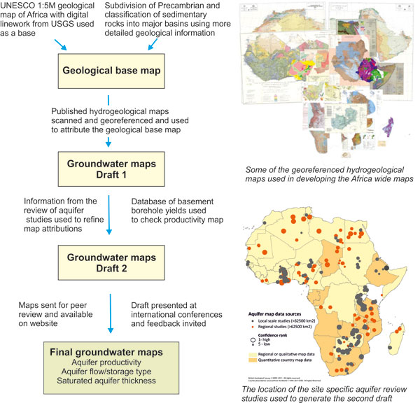
Methodology used to develop the groundwater maps for Africa. BGS © UKRI.
Every effort was made to use all available information, including:
- reliable geological base maps
- all available national, regional and subnational hydrogeological maps
- 250 papers and documents reporting groundwater studies in Africa
- good information on borehole yields for basement rocks
The final drafts were sent for peer review to experts in African groundwater.
Reports
- Digital groundwater maps of Africa
- Quantitative maps of groundwater resources in Africa article from Environmental Research Letters
- Review of aquifer properties data
- Review of recharge studies
Contact
Please contact Alan MacDonald for more information.