
The major aims of the Indo-Gangetic Basin aquifer research project were to:
- develop a strategic overview assessment of the occurrence and status of groundwater resources in the Indo-Gangetic basin
- determine the response of the different groundwater resources to climate and abstraction
- understand how these responses may evolve in the future
Groundwater typologies were developed to systemise the hydrogeological data collated within the review and highlight areas of different groundwater behaviour, that could require different management strategies.
Basin-wide assessment of main hydrogeological data
Within the basin-wide assessment, we systematically reviewed the main hydrogeological data available in the region to provide an overview of groundwater response to climate and abstraction in different parts of the basin. The review covered the whole of the Indo-Gangetic alluvium basin (Pleistocene to Holocene in age), stretching from the Sindh region in Pakistan to the Lower Ganges and Brahmaputra basins in Bangladesh. It includes both the plain and the intermontane regions at the margins of the basin (Figure 1).


Figure 1 Spatial extent of Indo-Gangetic alluvium basin. BGS © UKRI.
Dealing with uncertainty
A significant range of data types of differing quantity, age, source, spatial coverage and quality have been reviewed in the large-scale review to help devise and describe the groundwater typologies. Systematic criteria have been applied to assign confidence to individual studies reviewed, and the final typologies developed. This is essential to be able to assign a confidence to final project outputs when using a diverse range of datasets (Figure 2).
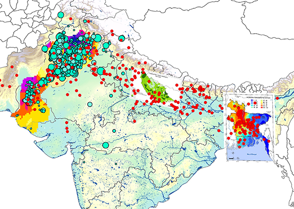
Figure 2 A large range of data types and sources were reviewed across the basin. All data were indexed within a project Access database and GIS, alongside confidence values and criteria. BGS © UKRI.
Groundwater typologies
The groundwater typologies encapsulate the hydrogeological data collated within the review and explore how groundwater levels respond to climate and abstraction within each typology.
The typologies take into account:
- current and future land use and management practices
- aquifer characteristics and potential fresh groundwater storage
- recharge mechanisms and quantities
- the dynamic response of groundwater to current climate and abstraction
Outputs
- Seven major groundwater typologies were developed for the basin (Figure 3):
- piedmont margin
- Upper Indus and Upper to Mid Ganges
- Lower Ganges and Mid Brahmaputra
- fluvial-influenced deltaic areas
- Middle Indus and Upper Ganges
- Lower Indus
- marine-influenced deltaic areas
- Details of these typologies and the methodology used to develop them are presented and described within the final project report

Figure 3 The main groundwater typologies of the Indo-Gangetic basin. BGS © UKRI.
Contact
Please contact Alan MacDonald for further information.