
The transboundary aquifer maps on groundwater abstraction, groundwater-level trend, salinity and arsenic (As) and estimated groundwater storage are available for download. Each map is available as a 1 km-resolution grid (XYZ ASCII file) and as high-resolution PDF files.


Children playing in pumped water in Khulna, Bangladesh. © Sultan Ahmed Niloy via pexels.com
The maps provide new, higher-resolution information of the Indo-Gangetic Basin aquifer at transboundary scale than previously available. They are based on a major systemic review of the best available, in situ observations and studies across the Indo-Gangetic alluvial aquifer. They are designed to show information at basin or regional scale.
Detailed description of the methodology and a full list of data sources used to develop the groundwater storage and productivity maps can be found in the peer-reviewed paper, published in Nature Geoscience.
Example maps

Groundwater-level trends map. Mean annual change in water-table levels across the aquifer during the period 2000 to 2010 (m/year). BGS © UKRI.
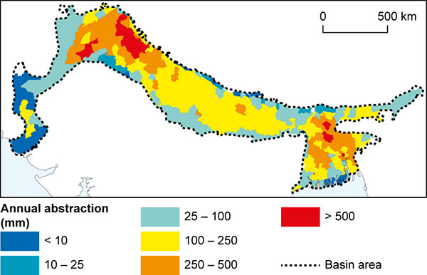
Groundwater abstraction map. Map of estimated mean annual groundwater abstraction across the aquifer based on data from 2010. BGS © UKRI.
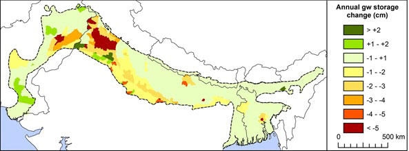
Groundwater storage change map. Map of estimated mean annual groundwater storage across the aquifer based on annual groundwater-level change and specific yield. BGS © UKRI.
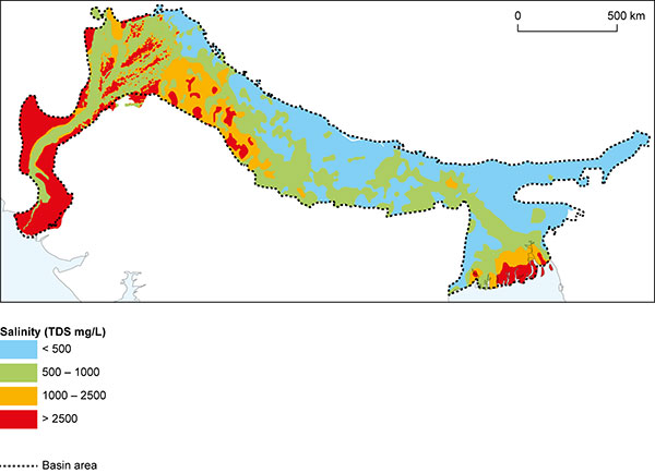
Groundwater quality: salinity map. Salinity measured as total dissolved solids in the groundwater across the aquifer. BGS © UKRI.

Groundwater quality: arsenic map. Areas where arsenic is known to be widespread, or thought likely to occur. BGS © UKRI.
Downloads
Further reading
MacDonald, A M, Bonsor, H C, Ahmed, K M, Burgess, W G, Basharat, M, Calow, R C, Dixit, A, Foster, S S D, Gopal, K, Lapworth, D J, Lark, M L, Moench, M, Mukherjee, A, Rao, M S, Shamsudduha, M, Smith, L, Taylor, R G, Tucker, J, van Steenbergen F, and Yadav, S K. Groundwater quality and depletion in the Indo-Gangetic Basin mapped from in situ observations. Nature Geoscience, Vol. 9, 762–766. DOI: https://doi.org/10.1038/ngeo2791
Terms and conditions
Please read the terms and conditions of usage of the maps.
Contact
Please contact Alan MacDonald for further information.