
The Eddleston Water is a small, upland tributary of the River Tweed in the Scottish Borders. It was selected as a demonstration research catchment by the Scottish Government for promoting natural flood management.


The Eddleston Water in Peebles, Scottish Borders.
Over time, as in many rural valleys, the course of the Eddleston Water has been channelised and straightened and the land has been drained to improve agricultural production. Such changes have caused a loss of habitat diversity and have increased the amount of rainwater run-off and the speed at which it flows through the catchment. These have led to an increased risk of flooding in Eddleston village and the town of Peebles downstream.
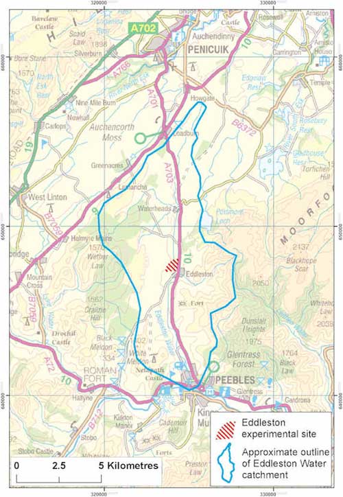
Location map showing the outline of the Eddleston Water catchment and the Eddleston experimental site. BGS © UKRI.
Eddleston Water floodplain project
The Eddleston Water floodplain project was a joint effort by a number of organisations to investigate and reduce the effects of flooding in the Eddleston catchment. A large part of the work was supported and funded by the Scottish Government.
In partnership with the University of Dundee, BGS carried out new research at a site near Eddleston village into the role groundwater plays in flooding in this kind of environment. Other work to investigate and reduce the impact of flooding in the Eddleston catchment was done by the Tweed Forum and the Scottish Environmental Protection Agency.
Groundwater throughout the Eddleston floodplain is closely linked to surface water (rivers, soil water and wetlands). Depending on the local environment and the weather, groundwater can mitigate, exacerbate or cause flooding. It is therefore important that natural flood management measures assess and take into account groundwater if they are to be fully effective.
The experimental site
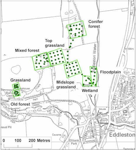
The site is approximately 0.3 km2 in area, which includes most of the width of the Eddleston Water floodplain on both sides of the river. It is a rural site, with a diverse range of land uses including:
- mixed livestock farming on improved grassland
- arable farming
- established forest shelter belts
- deciduous woodlands
- a riverbank strip of unimproved grassland

Eddleston Water in flood, 2012. BGS © UKRI.
Characterising the floodplain environment
Between summer 2010 and the end of 2011, BGS and the University of Dundee carried out extensive work to characterise the shallow, Quaternary subsurface environment — the glacial and post-glacial geology, hydrogeology and soil hydrology — of the experimental site at Eddleston.
The floodplain at Eddleston is underlain by a variable Quaternary valley fill sequence up to around 20 m thick.
From near the surface to approximately 5 to 7 m depth is a relatively continuous layer of alluvial sandy gravel, sometimes overlain by or interbedded with alluvial silt and fine sand or peat. From approximately 7 m to between 12 and 15 m depth is a layer of glaciofluvial gravel, which is largely restricted to the centre of the floodplain.
Below this are glaciolacustrine silts and clays. In some places, glacial till underlies the rest of the Quaternary sequence. Below the Quaternary deposits, bedrock across this whole area comprises greywackes — a form of sandstone — of Lower Palaeozoic age.
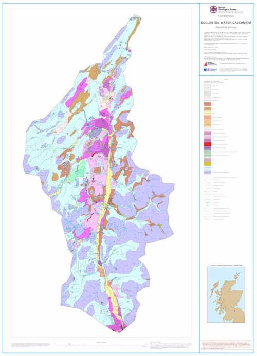
New geological map of the Eddleston Water catchment
As well as a detailed survey of the geology of the experimental site itself, BGS re-surveyed the Quaternary geology of the whole of the Eddleston Water catchment and produced a new map at 1:25 000 scale. To purchase the map as a hard copy or in pdf format, please contact BGS Enquiries (enquiries@bgs.ac.uk).
For more information about this mapping, and about licensing the data as GIS-enabled digital files, contact contact BGS Digital Data (digitaldata@bgs.ac.uk).
3D geology of the experimental site
A detailed 3D geological model of the Eddleston site was created by combining all the new geological and geophysical data from geological surveying, geophysical surveying, trial pit digging and borehole drilling. The geological model was produced using GSI3D geological software. As well as incorporating the new data collected on site, the model uses a high-resolution digital terrain model (DTM), which was derived from LiDAR data provided by Scottish Borders Council.
The completed model has been exported as a 3D pdf and was one of the first times this kind of technology was used to visualise geological information.
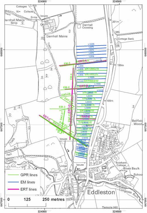
Three different types of near-surface geophysical surveys were carried out at the Eddleston site to help explore the shallow geology of the site. The techniques used were:
- electromagnetic induction (EM, also referred to as ground conductivity mapping)
- 2D electrical resistivity tomography (ERT)
- ground penetrating radar (GPR)
This combination of techniques is a common application in investigations of shallow Quaternary deposits and has been used successfully in a variety of BGS projects. The geophysical results were used to develop the 3D geological model and to help decide where to site the floodplain boreholes.
Cross-section
This is an example of an ERT geophysical cross-section across the floodplain, valley floor and the adjacent hill slope.

BGS © UKRI.
Groundwater in the Quaternary aquifers below the Eddleston Water floodplain is connected to water in the soil, to the river and to groundwater in the underlying bedrock aquifer. A large part of our work here involved investigating how groundwater in the floodplain interacts with water in the soil.
Sometimes it is hard to distinguish what is groundwater and what is soil water, because they are so closely linked.
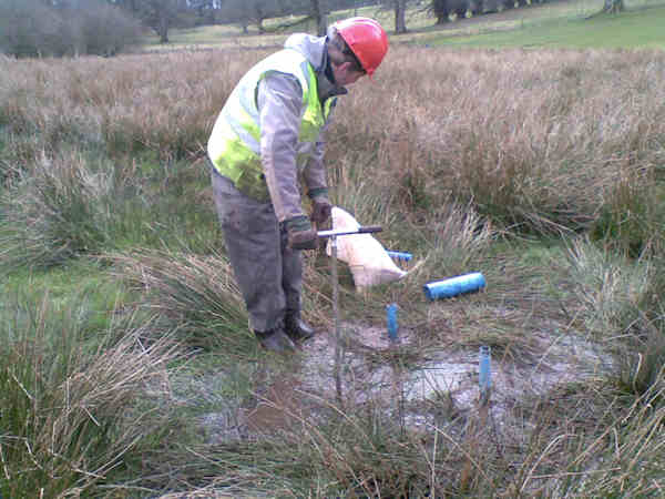
Borehole drilling into the floodplain
Nine boreholes were drilled into the Quaternary floodplain deposits at the Eddleston site, using a shell and auger (also called a percussion) drilling rig. We collected geological samples during drilling and produced detailed geological logs to show how the Quaternary deposits change both with depth and laterally across the floodplain. The data was invaluable for creating the 3D geological model.
The boreholes were drilled in pairs, with one shallow (typically 4 to 5 m) and one deep (typically 7 to 8 m) at each location. Piezometers were installed in the boreholes to test aquifer hydraulics and for ongoing groundwater monitoring. Most of the boreholes have only one piezometer, but two boreholes have a pair of nested piezometers at different depths, and one has a triplet of piezometers.
Hydraulic testing
Six smaller, shallower piezometers were installed by hand using a Dutch auger in a wetland area in one part of the site, as three pairs between ground level and 2 m depth. These were used to characterise the hydraulic properties of the soil and shallowest underlying Quaternary deposits, which help to control the hydrology of the wetland, and to monitor wetland hydrology over time.
Test pumping of the floodplain and the wetland piezometers was done to establish the hydraulic properties of the geological deposits. Three different pumps were used for testing, as the deposits have very different permeabilities. All the test pumping used constant rate tests, where the piezometer is pumped at a constant rate for between 100 and 360 minutes. The water level in the borehole is monitored during pumping and after the pump is switched off, until it recovers to its natural level.
The highest-yielding floodplain piezometers, which were installed in highly permeable sands and gravels, were tested with a suction pump with a capacity of approximately 2 litres per second (l/s). Lower-yielding floodplain piezometers constructed in moderately permeable sands and silts, were tested with an electric pump with a capacity of approximately 0.14 l/s.
The alluvial and glaciofluvial deposits show generally moderate permeability, with most measured transmissivity values from test pumping between 200 and 400 m2/day.
The University of Dundee, in partnership with BGS, has carried out a lot of work on soil permeability and soil water dynamics across the Eddleston site, which links closely with the groundwater investigations.
In some cases it’s hard to distinguish where the boundary is between soil water and shallow groundwater, which is why it is so important to consider both together in the floodplain environment.
Shallow wetland piezometers
The six smaller, shallower piezometers that were installed in the wetland area of the test site intercepted low-permeability silts and peat. They were used to characterise the hydraulic properties of these deposits, which are a major control the hydrology of the wetland, and to monitor wetland hydrology over time.
Installing shallow piezometers in a wetland area using a Dutch auger. BGS © UKRI.The shallow piezometers were first tested to establish the hydraulic properties of the silts and peat underlying the wetland. This was done with a peristaltic pump, which has a very low flow rate of between 40 ml/min and 3.5 l/min, using a rapid recovery method (sometimes known as a slug test), where the piezometer is rapidly pumped dry and the time taken for the water level to recover to its natural level is recorded.
Soil moisture sensors on the hill slope
Six sensors were also installed in soils on the hill slope above the wetland area, in two groups spaced 10 m apart up the slope. A hole was dug for each group and sensors placed at 20 cm, 35 cm and 60 cm depth. Then the hole was filled in again, leaving the sensors buried so they can monitor soil moisture.

Soil moisture sensors being installed at 20 cm, 30 cm and 60 cm depth beneath the hill slope at Eddleston. BGS © UKRI.
Soil permeability across the hill slope and floodplain
The University of Dundee carried out an extensive survey of soil permeability below different land covers across the hill slope and floodplain at the Eddleston site, supported by colleagues at the Centre of Excellence for Ecohydrology at the University of Western Australia.
Two different methods were used:
- surface soil permeability was measured using a ponded disc permeameter: a metal ring was sunk 4 mm into the ground; the permeameter was placed on the soil surface and a free flow of water was allowed to infiltrate the ground. The rate at which it infiltrated was then measured
- subsoil (below 4 cm) permeability was measured using a constant head well permeameter: an auger was used to dig a 15 cm-deep hole, which was filled with water at a constant rate. The rate at which the water soaked into soil below the hole was recorded.
Preliminary results showed that soil permeability was significantly higher between established woodlands than beneath grasslands used for grazing. This will affect rainfall infiltration and groundwater recharge.
To help us understand how groundwater flows through the floodplain and interacts with rain, soil and river water, the project sampled and analysed the chemistry of groundwater and surface water across the Eddleston site at different times of the year.
To collect groundwater samples, we use a small electrical pump powered by a 12V battery to purge the borehole and ensure that we had fresh groundwater from the aquifer.
As well as collecting samples for laboratory analysis of inorganic groundwater chemistry and environmental tracers such as stable isotopes and dissolved gases, we measured parameters like water temperature, acidity/alkalinity and oxygen content in the field, as these can change quickly once groundwater is exposed to air.
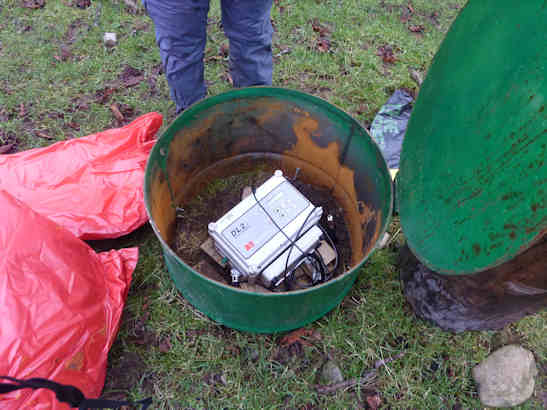
Groundwater levels and temperature were monitored across the floodplain using automatic sensors installed in the piezometers. These sensors made and recorded measurements every 15 minutes, and every few months we downloaded the data from them using a laptop and took it back to the office.
Geology maps and models
- 3D geological model in PDF
- New geological map of the Eddleston Water catchment: Eddleston Water Catchment, Superficial Geology, 1: 25 000 Scale
Data report
Ó Dochartaigh, B E, MacDonald, A M, Merritt, J E, Auton, C A, Archer, N, Bonell, M, Kuras, O, Raines, M G, Bonsor, H C, and Dobbs, M. 2012. Eddleston Water Floodplain Project: data report. British Geological Survey Open Report OR/12/059 (Nottingham, UK: British Geological Survey.)
Conference papers
Ó Dochartaigh, B E, MacDonald, A M, Archer, N A L, Black, A R, Bonell, M, Auton, C A, and Merritt, J E. 2012. Groundwater/surface water interaction in an upland hill slope floodplain environment, Eddleston, Scotland. BHS 11th National Symposium, Hydrology for a Changing World, Dundee, Scotland, 9–11 July 2012.
Archer, N A L, Bonell, M, Coles, N, MacDonald, A M, Stevenson, R, and Hallett, P. 012. The relationship of forest and improved grassland to soil water storage and its implication on natural flood management in the Scottish Borders. BHS 11th National Symposium, Hydrology for a Changing World, Dundee, Scotland, 9–11 July 2012.
Contact
Please contact BGS Enquiries (enquiries@bgs.ac.uk) for more information.