Geological Survey of Scotland
By 1854 the Geological Survey in England and Wales had been progressing since 1835 and in Ireland slightly longer.
It was at this time that Sir Henry De la Beche considered the extension of the Survey to Scotland, and he asked A.C. Ramsey to 'break the ground' in Scotland.
It was also at this time that consideration of the base mapping scale was hotly debated.
In England and Wales, mapping proceeded on base maps that were a scale of one inch to the mile, while in Ireland mapping was done in greater detail at the scale of six inches to the mile. A.C. Ramsay was intent on following the Irish method.
Beginnings
In August 1854 Ramsey, De La Beche, the Local Director for England and Wales, Jukes (Director of the Irish Survey), and Ramsay met in Glengarriff at Bantry Bay in Ireland.
It was here, after discussion, that the nature of the Geological Survey of Scotland was decided. The survey was to proceed at the scale of six inches to the mile.
Later in 1854, in the Autumn, Ramsay began work in the Dunbar area, mapping the Carboniferous and the Old Red Sandstone. The following year, two other young geologists were sent up to continue the mapping, H.H. Howell and Archibald Geikie.
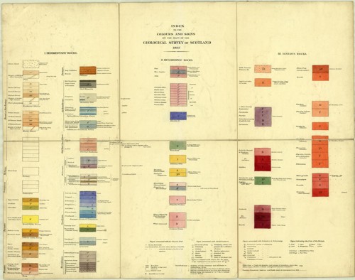
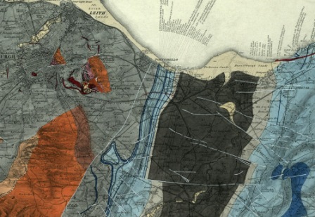
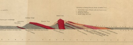
They mapped large tracts of the Lothians and Borders culminating in the publication of the hand-coloured, one inch to one mile, geological sheet 32 of Edinburgh. In about 1861 it was decided to map the superficial deposits, which in Scotland is mostly glacial drift, clays, sands and gravels laid down by the retreat of glaciers, and to show them on the one-inch to the mile published sheets. This entailed remapping previous areas as well as new areas.
New identity
A new separate identity was created for the Geological Survey of Scotland in 1869. R.I. Murchison, the then Director General set up a headquarters office in Edinburgh and A. Geikie was made the Director. A well known group photograph of the Survey staff taken in 1868 shows the staff J. Geikie, J. Horne, J. Croll, C.R. Campbell, B.N. Peach, D.R. Irvine, T.M. Skae and R.L. Jack.
For the first 20 years of its existence mapping was focused on the southern and central parts of Scotland. Maps and memoirs of the coalfield areas were published as well as adjacent non-coalfield areas. 'Clean copies' of the six-inch field slips were made at the same scale for public consultation in the Survey's offices.
Attention turns towards the Highlands
As the survey of the Central Belt and the adjacent areas matured, in 1875, attention turned towards the Highlands. Work initially started in the Old Red Sandstone on the southern margins of the Highlands but soon extended into the Moray Firth and Grampians area.
In 1882 A. Geikie became the Director General of the whole Survey and wanted to speed up and complete the primary survey of the UK. After a brief experiment changing to one-inch to one mile primary surveying, which proved to be very inadequate to convey the complex geology, the mapping team was increased. Despite this increase, the nature of the terrain, weather and complex geology resulted in slow progress.
For many years, since around 1860 a major geological controversy had existed between R.I. Murchison and Professor Nicols of Aberdeen over the nature of the succession for the North West Highlands. Charles Lapworth had also considered the problem. Geikie thought detailed mapping of the area would resolve the issue so he pulled together a very experienced mapping team of Ben Peach and John Horne and later Clough, Hinxman, Cadell and Gunn. By 1884 they had resolved the issue and together with Lapworth, they agreed that the upper rocks had been pushed over the lower rocks in a very low angle thrust fault.
Economic activity
From the early days of the Survey in Scotland there had been work related to economic activity especially the coal and oil shale resources.
Indeed, the whole oil-shale industry really developed when Geikie after his detailed mapping showed James (Paraffin) Young the main outcrops of the oil shales.
For much of the time there was a focus on mapping the coalfield areas and making the detailed 'clean copies' available for consultation. In the 1890s Grant Wilson started to collect information with a view to revising the mapping of the coalfield areas as a result of increase demand for these resources.
Southern Uplands
Subsequent to the first and very rapid survey of the Southern Uplands, Charles Lapworth had developed the view that graptolites provided the key to deciphering the stratigraphy of the folded and faulted Palaeozoic rocks.
Peach and Horne were called in to revise the mapping. So, between 1888 and 1898 they resurveyed the area, working in the winter months while summers were spent in the Highlands.
Their two great memoirs were subsequently published, for the Southern Uplands in1888, and for the North West Highlands in 1907.
Bibliography
Bailey, E B. 1952. Geological Survey of Great Britain. (London: Murby.)
Flett, J S. 1937. The first hundred years of the Geological Survey of Great Britain. (London: HMSO.)
McIntosh, R P. 2012. Geological Survey of Great Britain and Ireland - a contemporary account of the Survey, 1897 (3.17 MB pdf). Extract and illustrated from 1897 Geological Survey of Great Britain. Summary of Progress (unpublished).
McKenna, G. (Ed) [Unpublished manuscript]. Instructions for the Local Directors of the Geological Survey of Great Britain and Ireland (330 KB pdf) by Henry De la Beche 22nd May 1845. Selected documents from the BGS Archives No. 1
Wilson, Harry. 1985. Down to earth: one hundred and fifty years of the British Geological Survey. (Edinburgh: Scottish Academic press.)
Wilson, R B. 1977. History of the Geological Survey in Scotland (4.3 MB pdf). (Edinburgh : Institute of Geological Sciences.)
