
The successful and sustainable development of groundwater resources in Africa is critical for future safe water supplies, economic growth and food security across the continent. This depends on a good understanding of groundwater and hydrogeology but too often, high-quality existing information about groundwater in Africa is hard to find and access. The Africa Groundwater Atlas, an online resource that provides an introduction to the groundwater resources of 51 African countries, aims to address this problem, providing a gateway to further information.
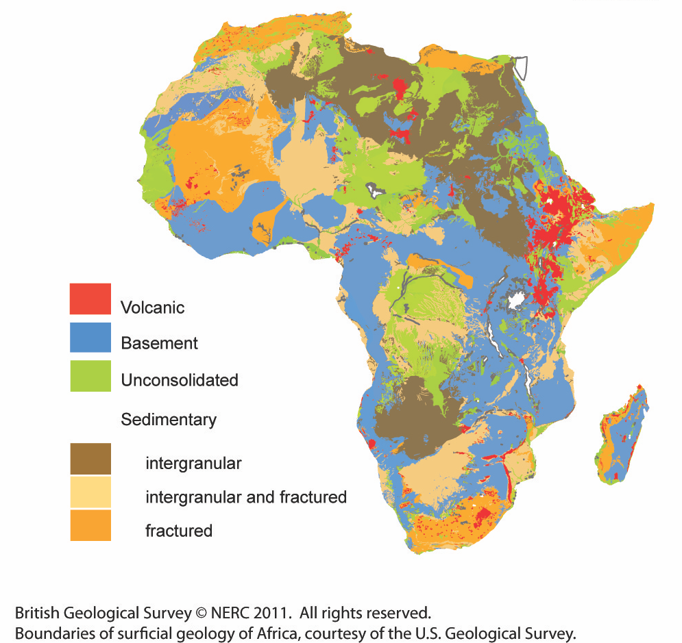

Hydrogeological environments across Africa. BGS © UKRI.
The Africa Groundwater Atlas was developed by the BGS in collaboration with the International Association of Hydrogeologists (IAH) Burdon Groundwater Network for Developing Countries. More than 50 groundwater scientists across Africa co-authored country summaries. Along with the accompanying Africa Groundwater Literature Archive, the atlas is a platform that publicises expert knowledge of African groundwater.
National groundwater resources
For each of 51 African countries, the Africa Groundwater Atlas provides:
- a summary of the hydrogeology of the country’s main aquifers, backed by new overview maps
- sections on groundwater status, use and management (including groundwater monitoring) with up-to-date information on the key organisations in each country involved in groundwater development and management
- background information about geographical setting, climate, surface water features, soil and land cover, with accompanying maps
- lists of further information sources and references, with online links where possible
Supporting information at continental scale
The atlas also includes a series of pages that provide supporting information and links to further resources on many different areas of African groundwater and hydrogeology, including:
- the main hydrogeological environments across Africa
- appropriate recharge estimation techniques for African environments
- the best methods for developing groundwater resources
- information on transboundary aquifers
Other resources
Another part of this project has been the development of the Africa groundwater literature archive, a searchable, online database of literature about groundwater in Africa.
Why is this project important?
The availability and accessibility of robust groundwater data and information is a major constraint to developing groundwater resources across Africa, and is an additional barrier to undertaking research. The primary aim of this project was to provide detailed and appropriate information on African groundwater resources to a range of stakeholders, such as:
- policy and decision makers who need an overview of groundwater conditions and issues in a country
- hydrogeologists and other practitioners developing groundwater supplies and looking for information and data on groundwater conditions in specific regions or countries
- researchers looking for information and data on African groundwater to support their investigations
Future improvements
The Africa Groundwater Atlas is still being developed. Some of the pages still have limited information and, for many others, there may be more details to be added or updates to be made. If you have or know of information or resources that could help us improve the Atlas, please get in touch (enquiries@bgs.ac.uk).
Funding
The Africa Groundwater Atlas project is being carried out by BGS in partnership with African hydrogeologists and is jointly funded by:
It is a part of the Unlocking the Potential for Groundwater for the Poor (UPGro) Research Programme, which focuses on improving the evidence base around groundwater availability and management in sub-Saharan Africa, to enable the sustainable use of groundwater that benefits the poor.