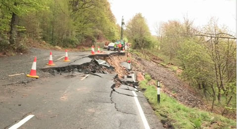
On Boxing Day 2012, a landslide started to deform a 300 m section of the B6344 road between Rothbury and Weldon Bridge, immediately west of Cragend Farm in Northumberland. Over the following weeks and months, the landslide continued to move and gradually destroyed the road.
A long detour was put in place and this put additional strains on the communities, in terms of extra travel cost, revenue lost and travel time. Following an appeal for assistance, the government made funds available to enable the reconstruction of the B6344, but this was anticipated to run well into 2014.
In summer 2013, the BGS Landslide Response Team visited the site to learn more about the landslide mechanisms involved.

BGS © UKRI.
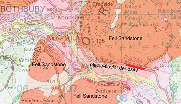
The section of the B6344 affected by the landslide processes is marked with a red line. BGS © UKRI.
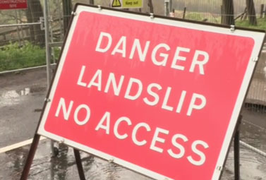
Signs of instability along the B6344 east of Rothbury in Northumberland, UK. Contains Ordnance Survey data © Crown Copyright and database rights 2021.
Geology
The Carboniferous bedrock of this region mainly comprises sandstones from the Fell Sandstone Formation. East of the landslide site is a series of sedimentary rock cycles of the Alston Formation, generally covered by substantial glacial till deposits from the Devensian. To the west of the site, interbedded limestone and mudstone sequences of the Tyne Limestone Formation are found.
The valley of the river Coquet was active during glacial periods and left widespread glacio-fluvial deposits, containing a variety of gravel, sand and silt sequences. These deposits drape the valley sides, reaching elevations some 60–80 m above the current stream bed. At the site of the landslide, the slopes below the B6344 leading down to the Coquet are formed in these glacio-fluvial deposits and this is likely to have contributed to the failure of the slope.
Landslides and rainfall
The wet summer of 2012 resulted in an increased incidence of landsliding across Great Britain and rainfall appears to have played an important part in the process leading to the onset of the Rothbury landslide.
Before April 2012, the precipitation over north-east England was following a pattern that was drier than the long term average. However, the region then experienced a long series of wet events, at first leading to the ‘wettest drought on record’, where the landscape was catching up with the water being delivered. But then the rains continued, soaking the landscape and making it much more sensitive to landsliding.
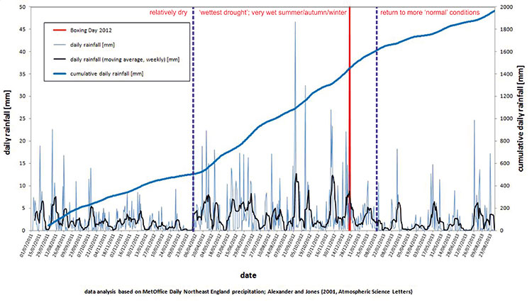
Daily rainfall in north-east England in 2012 and 2013, showing when the Rothbury landslide took place. BGS © UKRI.
Slope response to rainfall events
Because of the many different ways in which water moves through the slopes of landscapes, some of them will respond quickly to rainfall events while others will take a bit longer. The local geology around Rothbury comprises sandstone and this type of bedrock is capable of allowing water to flow through it. In addition to the direct effects of rainfall, it is likely that the slopes were de-stabilised due to the flow of groundwater through the bedrock and the glacio-fluvial deposits covering it. Several issues and springs had also been observed and mapped in the fields below the road.
The slope below the B6344 gradually became more and more unstable until, on Boxing Day 2012, it started to move seriously and destroyed the road.
Interestingly, this landslide occurred towards the end of the wet period of 2012–2013 and only a couple of months later, precipitation conditions started to follow a more ‘normal’ trend.
Gallery
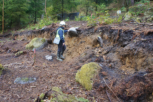
Dr Claire Dashwood of the BGS Landslide Response Team investigating the head of the landslide above the B6344, east of Rothbury, Northumberland. BGS © UKRI.
Dr Helen Reeves of the BGS Landslide Response Team investigating the landslide along the B6344, East of Rothbury, Northumberland. BGS © UKRI.
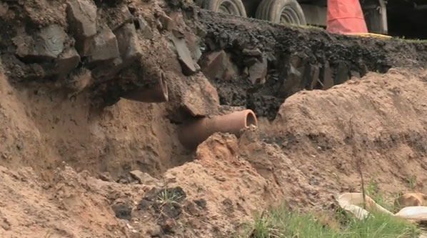
A drainage pipe cut by the landsliding process. BGS © UKRI.
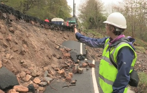
The BGS Landslide Response Team at the landslide along the B6344, east of Rothbury, Northumberland. BGS © UKRI.
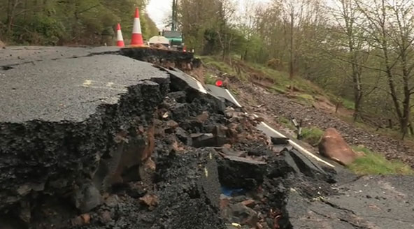
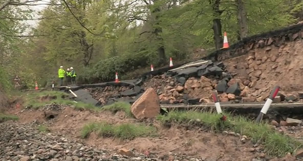
The landslide along the B6344, east of Rothbury, Northumberland. BGS © UKRI.
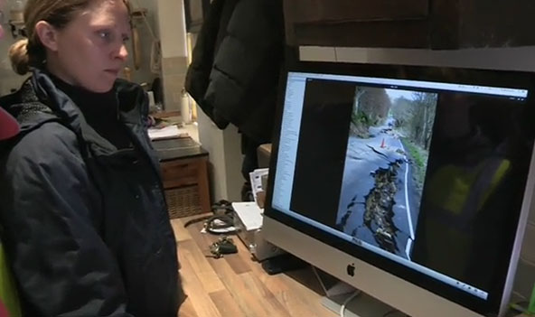
Dr Claire Dashwood analysing a sequence of photographs showing the gradual development of the landslide along the B6344, east of Rothbury, Northumberland. BGS © UKRI.
You may also be interested in

Landslide case studies
The landslides team at the BGS has studied numerous landslides. This work informs our geological maps, memoirs and sheet explanations and provides data for our National Landslide Database, which underpins much of our research.

Understanding landslides
What is a landslide? Why do landslides happen? How to classify a landslide. Landslides in the UK and around the world.

How to classify a landslide
Landslides are classified by their type of movement. The four main types of movement are falls, topples, slides and flows.

Landslides in the UK and around the world
Landslides in the UK, around the world and under the sea.