Key information
Scale:
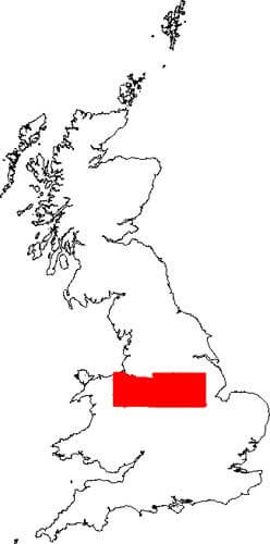
400 m flight line separationCoverage:
North Midlands of England into Welsh BorderlandAvailability:
FreeFormat:
ASCII text records and GeoTIFFsPrice:
Free for commercial, research and public use under the Open Government Licence. Please acknowledge the material
Uses:
Local-level to regional-level useGet data
Free access
Our free data is available under the Open Government Licence. Please acknowledge reproduced BGS materials.
View onlineWeb service (OGC WMS) – Geophysics theme.Supporting documents
The BGS and World Geoscience Corporation Ltd (WGC) collaborated on survey flying for the high-resolution geophysical and environmental survey, which was completed in 1998.
The data comprises multichannel gamma ray spectrometer, magnetometer and dual-frequency VLF-EM. Flight-line spacing was 400 m with tie lines at 1200 m. The total area surveyed was some 14 000 km2. Flight-line orientations were west to east over the western survey area and south-west to north-east over the eastern area. Ground clearance was maintained at 90 m in rural areas, increasing to about 240 m in built-up zones.

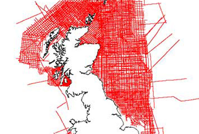
Hi-RES1 airborne magnetic, radiometric, VLF survey coverage. BGS © UKRI – Contains OS data © Crown copyright 2020.
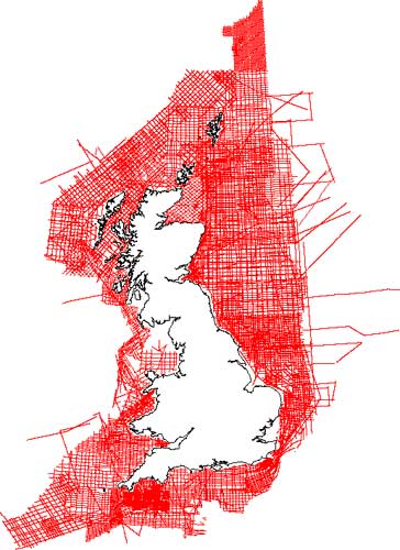
Hi-Res1 airborne magnetic, radiometric, VLF survey coverage. BGS © UKRI – Contains OS data © Crown copyright 2020
You may also be interested in:

Marine magnetic survey
204 724 line-kilometres of offshore ship-borne magnetic survey data that the BGS acquired on the UK continental shelf between 1967 and 1994
Marine gravity survey
218 760 line-kilometres of ship-borne gravity survey data that the BGS acquired on the UK continental shelf between 1968 and 1990.