Sidestrand is situated 1.3 km south-east of the village of Overstrand on the Norfolk coast. The cliff faces north-east and the beach is very wide and sandy.
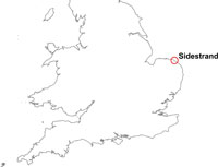

Sidestrand, Norfolk, location map. BGS © UKRI.
Sidestrand is part of a programme of work monitoring coastal erosion and landsliding at several sites around the coast of Great Britain. Active, deep-seated rotational landslides and mudslides predominate and BGS has been collecting data from this site since 2001. This is National Landslide Database ID 16350/1.
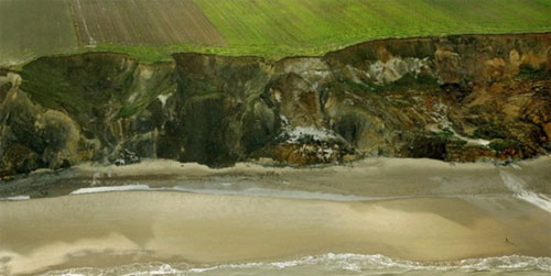
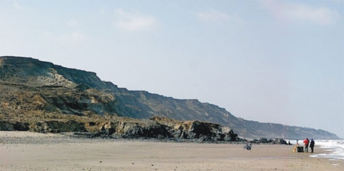
Sidestrand coastal section. © Mike Page, SkyView.
Geology
A considerable amount of work has been carried out on the local geology (Banham, 1988; Hart and Boulton, 1991; Lunkka, 1994; Hamblin, 2000; Lee et al., 2004), and, to a much lesser extent, the geotechnical properties of the tills of North Norfolk (Kazi and Knill, 1969; Hutchinson, 1976).
The current geological interpretation is that of Lee et al. (2004). This scheme equates the Lowestoft Formation (formerly the Lowestoft Till) with the so-called Second Cromer Till.
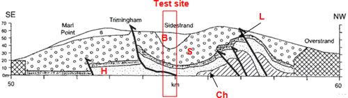
Coastal section; taken from Lee et al., 2004.
B = Briton’s Lane Formation, S = Sheringham Cliffs Formation, L = Lowestoft Formation, H = Happisburgh Formation, Ch = Chalk/pre-glacial, hachuring = obscured by defences; black arrows = thrust faults.
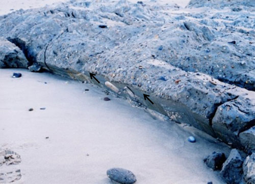
Important features of the landslide site and neighbouring cliffs are the glaciotectonically controlled syncline and large-scale shears (Lee et al., 2004). The deposits within the platform and lower part of the cliff consist of the matrix-dominant, dark grey Happisburgh Till Member of the Happisburgh Formation. This till has been subjected to small-scale,, glaciotectonic folding and, as with most tills of this type, is regularly jointed. The folding is observed in freshly eroded or landslide-exposed sections in the cliff and in the platform.
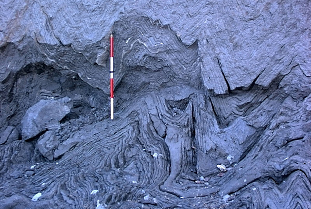
Happisburgh Till Member showing chevron folding. The ranging rod is 1 m long. BGS © UKRI.
The deposits in the mid part of the cliff are largely obscured by landslides. They consist of:
- Ostend Clay Member (Happisburgh Formation)
- Walcott Till Member (Lowestoft Formation)
- the lower and central components of the Sheringham Cliffs Formation:
In the upper part of the cliff the exposure is good. Here the uppermost part of the Sheringham Cliff Formation (Trimingham Clay and Weybourne Town Till members) is seen. This is overlain by the Stow Hill Sand and Gravel Member of the Briton’s Lane Formation.
The Happisburgh Till Member is a 3–6 m-thick, massive, yellow-brown. sandy till, while the Walcott Till Member is a stiff, blue-grey, chalky, flinty till.
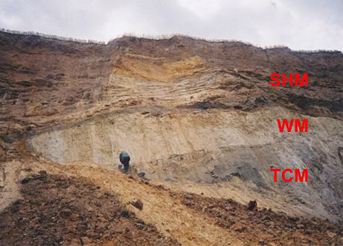
Trimingham Clay Member (TCM), Weybourne Town Till Member (WM) and Stow Hill Sand and Gravel Member (SHM). BGS © UKRI.
Virtually the entire thickness of the Briton’s Lane and Sheringham Cliffs formations has been subject to glaciogenic thrusting (Lee et al., 2004). Distinguishing syndepositional and postdepositional thrust/shear features from modern landslide features is difficult in some cases. Some shear features visible in marine-eroded cliff sections are clearly the basal and side-shears of modern mudslides.
Landslides
The landslides at the Sidestrand test site are complex, consisting partly of large-scale, deep-seated landslides and partly of mudslides and debris flows.
The deep-seated movements tend to have a dominant rotational component, but are in part translational. In some cases, these extend to depths several metres below platform level, but are more usually entirely within the cliff. The backscarps at the cliff top tend to be sharply defined, vertical features that persist after the landslide event. The landslides form deeply incised embayments that are arcuate in plan.
Deep-seated landslides tend to rotate to angles of 10–20° and break up during failure transport, producing large debris aprons that spread across beach and platform. These are short-lived, as the debris is readily removed by the sea. Such large events are followed by many mudslides and mudflows.
The level of activity during the survey period was high, particularly during the winter of 2000/01. It included various types of movement at beach level and a large-scale debris flow, which ran out across the beach and persisted for two years. Active beach thrusting and deep-seated rotation have been observed periodically.
Deep-seated rotational landslide thrusting up through the beach at Sidestrand. BGS © UKRI.
Large debris flow of winter 2001/02. BGS © UKRI.
The BGS Landslide Response Team carrying out a survey of the large debris flow of winter 2001/02 (photograph taken in April 2002). BGS © UKRI.
Survey results
As part of a cliff monitoring programme at BGS, data was collected from the cliffs at Sidestrand annually for six years. The principal method of survey is long-range terrestrial laser scanning (terrestrial LiDAR).
The annual surveys’ results were processed to provide data for models of coastal recession. The data collected in the field by laser scanning and GPS were entered into a modelling package and the resulting computer model enables volume calculations and observations as to the way in which the coast is eroding.
Gallery
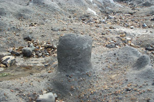
Unusual shapes created by marine erosion of the Happisburgh Formation. BGS © UKRI.
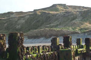
A flow at Sidestrand that overtopped the wooden palisade coastal defences. BGS © UKRI.
Chevron folding in the Happisburgh Till Member at Sidestrand. BGS © UKRI.
Chevron folding in the Happisburgh Till Member at Sidestrand. BGS © UKRI.
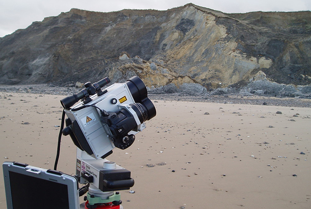
Terrestrial LiDAR in action at Sidestrand. BGS © UKRI.
Change in cliff profile
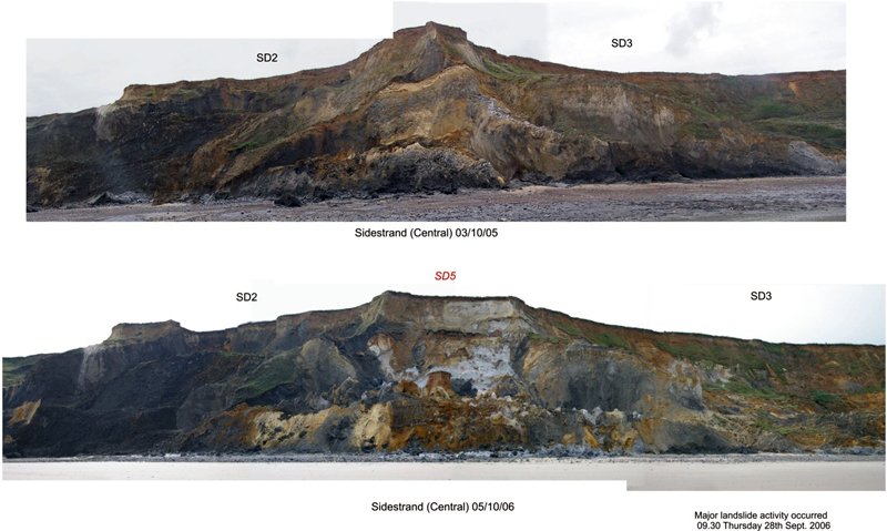
How the central cliffs changed from 2005 to 2006. BGS © UKRI.
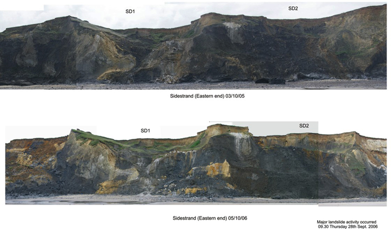
How the eastern cliffs changed from 2005 to 2006. BGS © UKRI.
More information
Banham, P H. 1988. Polyphase glaciotectonic deformation in the contorted drift of Norfolk. 27–32 in Glaciotectonics; Forms and Processes. Croot, D G (editor). (Rotterdam, Netherlands: Balkema.)
Hamblin, R J O. 2000. A new glacial stratigraphy for East Anglia. Mercian Geologist, Vol. 15(1), 59–62.
Hart, J K, and Boulton, G S. 1991. The glacial drifts of Norfolk. 233–243 in Glacial Deposits in Great Britain and Northern Ireland. Ehlers, J, Gibbard, P L, and Rose, J (editors). (Rotterdam, Netherlands: Balkema.)
Hutchinson, J N. 1976. Coastal landslides in cliffs of Pleistocene deposits between Cromer and Overstrand, Norfolk, England. 155–182 in Laurits Bjerrum Memorial Volume: Contributions to Soil Mechanics. Janbu, N, Jorstad, F, and Kjaernsli, B (editors). (Oslo, Norway: Norwegian Geotechnical Institute.)
Kazi, A, and Knill, J L. 1969. The sedimentation and geotechnical properties of the Cromer Till between Happisburgh and Cromer, Norfolk. Quarterly Journal of Engineering Geology, Vol. 2, 63–86.
Lee, J R, Booth, S J, Hamblin, R J O, Jarrow, A M, Kessler, H K E, Moorlock, B S P, Morigi, A M, Palmer, A, Pawley, S J, Riding, J B, and Rose, J. 2004. A new stratigraphy for the glacial deposits around Lowestoft, Great Yarmouth and Cromer, East Anglia, UK. Bulletin of the Geological Society of Norfolk, Vol. 53, 3–60.
Lunkka, J P. 1994. Sedimentation and lithostratigraphy of the North Sea Drift and Lowestoft Till Formations in the coastal cliffs of northeast Norfolk, England. Journal of Quaternary Science, Vol. 9(3), 209–233.
Banham, P H. 1968. A preliminary note on the Pleistocene stratigraphy of northeast Norfolk. Proceedings of the Geological Association, Vol. 79, 507–512.
Banham, P H, and Ranson, C E. 1965. Structural study of the contorted drift and disturbed Chalk at Weybourne, North Norfolk. Geological Magazine, Vol. 102(2),165–174.
Bell, F G. 2002. The geotechnical properties of some till deposits occurring along the coastal areas of eastern England. Engineering Geology, Vol. 63, 49–68.
Bell, F G, and Forster, A. 1991. The geotechnical characteristics of the Till deposits of Holderness. 111–118 in Quaternary Engineering Geology. Forster, A, Culshaw, M G, Cripps, J C, Little, J A, and Moon, C F (editors). Engineering Geology Special Publications, Vol. 7. (London, UK: Geological Society.)
Buckley, S J, Howell, J A, Enge, H D, and Kurz, T H. 2008. Terrestrial laser scanning in geology: data acquisition, processing and accuracy considerations. Journal of the Geological Society of London, Vol. 165, 625–638.
Cambers, G. 1976. Temporal scales in coastal erosion systems. Transcripts of the Institute of British Geographers, Vol. 1, 246–256.
Cameron, T D J, Crosby, A, Balson, P S, Jeffery, D H, Lott, G K, Bulat, J, and Harrison, D J. 1992. United Kingdom Offshore Regional Report: the geology of the southern North Sea. (London, UK: HMSO.)
Clayton, K M. 1989. Sediment input from the Norfolk cliffs, Eastern England – a century of coast protection and its effects. Journal of Coastal Research, Vol. 5(3), 433–442.
Clayton, K M, McCave, I N, and Vincent, C E. 1983. The establishment of a sand budget for the East Anglian coast and its implications for coastal stability. 91–96 in Shoreline Protection. (UK: Thomas Telford Ltd.)
da Fontura Klein, A H, and de Menezes, J T. 2001. Beach morphodynamics and profile sequence for a headland bay coast. Journal of Coastal Research, Vol. 17(4), 812–835.
Hobbs, P, Humphreys, B, Rees, J, Tragheim, D, Jones, L, Gibson, A, Rowlands, K, Hunter, G, and Airey, R. 2002. 589–600 in Monitoring the Role of Landslides in ‘Soft cliff’ Coastal Recession. McInnes, R G, and Jakeways, J (editors). (Isle of Wight, UK: Instability Planning and Management, Thomas Telford.)
Hobbs, P R N, Pennington, C V L, Pearson, S G, Jones, L D, Foster, C , Lee, J R, and Gibson, A. 2008. Slope Dynamics Project Report: Norfolk Coast (2000-2006). British Geological Survey Open Report OR/08/018. (Nottingham, UK: British Geological Survey.)
H R Wallingford, Posford Haskoning, and D’Oller, B. 2002. Southern North Sea Sediment Transport Study Phase 2: Sediment Transport Report. Report for Great Yarmouth Borough Council, Report EX 4526.
Knight, J. 2005. Formation of thrust structures in front of coastal landslides. The Journal of Geology University of Chicago, Vol. 113, 107–114.
Lee, J R. 2001. Genesis and palaeogeographic significance of the Corton Diamicton (basal member of the North Sea Drift Formation), East Anglia, UK. Proceedings of the Geologists’ Association, Vol. 112, 43–67.
Lee, J R, Rose, J, Hamblin, R J O, and Moorlock, B S P. 2004. Dating the earliest lowland glaciation of eastern England: a pre-M1512 early Middle Pleistocene Happisburgh Glaciation. Quaternary Science Reviews, Vol. 23, (14–15).
Lee, J R, Rose, J, Riding, J B, Hamblin, R J O, and Moorlock, B S P. 2002. Testing the case for a Middle Pleistocene Scandinavian glaciation in Eastern England: evidence for a Scottish ice source for tills within the Corton Formation of East Anglia, UK. Boreas, Vol. 31, 345–355.
McCave, I N. 1978. Grain-size trends and transport along beaches: examples from Eastern England. Marine Geology, Vol. 28, M43–M51.
McCave, I N. 1987. Fine sediment sources and sinks around the East Anglian coast (UK). Journal of the Geological Society of London, Vol. 144(1), 149–152.
Miller, L, and Douglas, B C. 2004. Mass and volume contributions to twentieth-century global sea level rise. Nature, Vol. 428, 406–409.
Mills, J P, Buckley, S J, Mitchell, H L, Clarke, P J, and Edwards, S J. 2005. A geomatics data integration technique for coastal change monitoring. Earth Surface Processes and Landforms, Vol. 30(6), 651–664.
Moorlock, B, Hamblin, R, Booth, S J, Woods, M, Kessler, H, and Hobbs, P. 2002. Geology of the Cromer District: a brief explanation of the geological map sheet 131 Cromer. (Nottingham, UK: British Geological Survey.)
Ohl, C, Frew, P, Sayers, P, Watson, G, Lawton, P, Farrow, B, Walkden, M, and Hall, J. 2003. North Norfolk – a regional approach to coastal erosion management and sustainability practice. 226–240 in International Conference on Coastal Management 2003: Brighton. McInnes, R G (editor). (UK: Thomas Telford.)
Poulton, C V L, Lee, J R, Jones, L D, Hobbs, P R N, and Hall, M. 2006. Preliminary investigation into monitoring coastal erosion using terrestrial laser scanning: case study at Happisburgh, Bulletin of the Geological Society of Norfolk, Vol. 56, 45–65.
Reid, C. 1882. The geology of the country around Cromer, Sheet 68. British Geological Survey.
Rowlands, K, Jones, L, and Whitworth, M. 2003. Landslide laser scanning: a new look at an old problem. Quarterly Journal of Engineering Geology, Vol. 36(2), 55–158.
Short, A D, and Masselink, G. 1999. Embayed and structurally controlled beaches. 142–161 in Handbook of Beach and Shoreface Morphodynamics. Short, A D (editor). (Chichester, UK: Wiley.)
Thomalla, F, and Vincent, C E. 2003. Beach response to shore-parallel breakwaters at sea palling, Norfolk, UK. Estuarine, Coastal and Shelf Science, Vol. 56, 203–212.
You may also be interested in

Landslide case studies
The landslides team at the BGS has studied numerous landslides. This work informs our geological maps, memoirs and sheet explanations and provides data for our National Landslide Database, which underpins much of our research.

Understanding landslides
What is a landslide? Why do landslides happen? How to classify a landslide. Landslides in the UK and around the world.

How to classify a landslide
Landslides are classified by their type of movement. The four main types of movement are falls, topples, slides and flows.

Landslides in the UK and around the world
Landslides in the UK, around the world and under the sea.