The Samburu-Marsabit Geological Mapping and Mineral Exploration Project was a joint Kenyan and British technical co-operation project, carried out by staff of the Mines and Geological Department, Ministry of Environment and Natural Resources, Kenya and staff from BGS. The first phase of the project commenced in 1980, and covered the area between 36° and 38° E and from the equator to 2° N. The second phase, carried out between 1984 and 1986 covered the area between 36° and 38° E and from 2° N to the Ethiopian border. Sampling was carried out concurrently with geological mapping and was largely constrained by the requirements of that exercise. Little or no sampling was done in areas previously mapped by other bodies. Sampling was mainly confined to areas underlain by basement rocks of the Mozambique Belt and was very sparse over most of the Tertiary and Quaternary volcanic cover.
Sampling densities varied considerably across the Phase 1 project area, but generally a stream sediment sample density of one per 4 to 8 km² and a panned concentrate density of one per 13 to 16 km¹ was achieved. In the Phase 2 area, which was mainly very arid, a few samples were collected from dry stream beds, as part of a helicopter survey of the area, to provide some idea of the geochemistry of the major lithological units.
Stream sediments were collected by combining grab samples from 5 to 10 points within a 10 m radius of the selected site. If necessary the samples were dried before being sieved and the fine (-80 mesh B.S.) fraction retained for analysis. Heavy mineral concentrates were obtained by taking 2 to 5 kg of material from the sample site and panning at the base camp, where water was available, or at the Mines and Geological Department headquarters at Nairobi.
The fine fraction from the stream sediment samples was analysed by atomic absorbtion spectroscopy (AAS), after digestion in hot 1:1 hydrochloric acid, for Ag, Ba, Co, Cu, Fe, Li, Mn, Mo, Ni, Pb, Sr and Zn. Initially the analyses were carried out in the laboratories of the Mines and Geological Department, but for a number of reasons it unfortunately became necessary to switch to Geosurvey International Ltd after approximately one quarter of the total number of samples had been processed. Precision of analysis was monitored at both laboratories by the submission of control samples and replicates. For the Mines and Geological Department the analytical precision generally varied between 20 and 40 per cent, depending on the element and concentration, the results being worst at low concentrations. For the Geosurvey analyses the precision was generally less than 20 per cent, except for Pb and Li. Analyses for Ag, Mo and Fe are not available from the British Geological Survey.
Pan Concentrates were analysed by X-ray fluorescence (XRF) at the Department of Geology, University of Nottingham. The elements determined were As, Ba, Bi, Co, Cr, Cu, Fe, La, Mn, Mo, Nb, Ni, Pb, Sn, Sr, Th, Ti, U, V, W, Zn, and Zr. Because of the small amounts of concentrate usually available it was not possible to monitor the precision of the XRF analyses using replicates, but the laboratory claims a figure of better than 8 per cent at the 100 ppm level for all the elements determined.
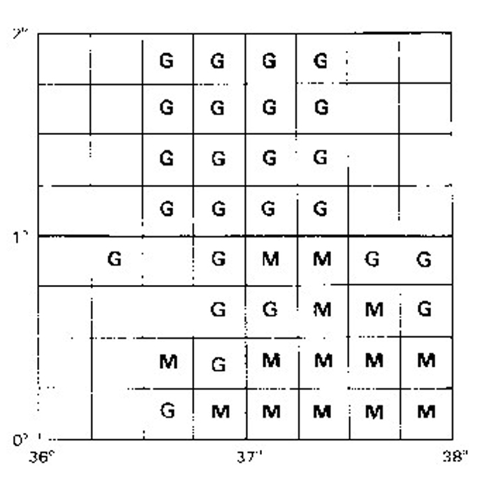

Source of stream sediment analyses by 1:50 000 topographic sheet. Phase 1: Relationship between 1:50 000 map sheets and the laboratory used to analyse the geochemical exploration samples. M = Mines and Geological Department; G = Geosurvey International Limited. From Hackman et al. (1989)
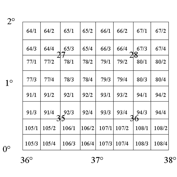
Sheet numbers for the Phase 1 area. 1:50 000 scale sheets are numbered and outlined in black and 1:250 000 scale sheets are numbered on line intersections.
| Degree Sheet | Number |
|---|---|
| 3+4 | 13 |
| 11 | 0 |
| 12 | 12 |
| 19 | 45 |
| 20 | 38 |
Number of samples (sediment + concentrate) collected in Phase 2 area: (Some of these analyses are reported in the sheet reports, but no complete dataset is available in the U.K.)
| AREA CODE (AREACODE) | Refers to the 1:50,000 topographic sheet number (see Introduction) without the (/) quarter-sheet divider. Where this runs to four figures, only the last three are used and leading zeros are omitted (e.g. 106/2 appears as 62 in the database). | ||
| DRAINAGE CONDITIONS (DRAINCON) | The drainage state at the time of collection: F Flowing; S seepage below stream bed; and D dry. | ||
| MORPHOLOGICAL DIVISION (MORPDIVS) | This parameter describes the land-forms around the sampling site | ||
| B | Dissected Basement | ||
| D | Dissected Volcanics | ||
| I | Inselbergs | ||
| M | Mountain Range | ||
| P | Piedmont | ||
| V | Volcanic Plateaux | ||
| SUPERFICIALS (SUPERF) | This parameter records important superficial deposits at the sampling site | ||
| A | Alluvium | ||
| B | Black Cotton Soil | ||
| C | Colluvium | ||
| K | Calcrete | ||
| L | Laterite | ||
| S | Aeolian sand | ||
| LITHOLOGY (LITH) | This parameter records the lithology at the sample site | ||
| A | Amphiobolite | N | Basalt |
| B | Biotite gneiss | O | |
| C | Colluvium | P | Acid intrusive |
| D | Basic intrusive | Q | Quartzite |
| E | Mylonite or Cataclastite | R | Mugearite |
| F | Phonolite | S | Aluminous gneiss |
| G | Graphite gneiss | T | Trachyte |
| H | Mafic gneiss | U | Ultramafic |
| I | Intermediate intrusive | V | Leuco-gneiss |
| J | Mica schist | W | Muscovite gneiss |
| K | Calcrete | X | Undifferentiated basement |
| L | Laterite | Y | Undifferentiated sed. rocks |
| M | Marble | Z | Migmatite |
Major geological units 1 and 2 (GEOL1 and GEOL2)
These parameters record the two most abundant lithostratigraphic groups in the catchment of the stream being sampled. It should be noted that the coding scheme used in the database seems to depart from that listed in Ridgway (1982), and consequently the data in these fields should be treated with caution.
| A | Don Dol gneisses with acid intrusives |
| B | Il Busi gneisses |
| C | Loldaika Complex |
| D | Don Dol gneisses |
| E | Lolkoitai gneisses with basic intrusives |
| F | Sirimum phonolites |
| G | Mukogodo Complex |
| I | Don Dol gneisses with basic intrusives |
| K | Kotim gneisses |
| L | Lolkoitai gneisses |
| M | Matoni gneisses |
| N | Basalts (un-named) |
| O | Ol Dionyo Ng’iro gneisses |
| Q | Mount Kenya volcanics |
| R | Rumuruti Group |
| S | Undifferentiated sediments |
| U | Undifferentiated migmatites |
| Y | Nyambeni volcanics |
Month of collection (Month)
A letter code has been used to record the month in which each sample was collected, to provide data for any seasonal variation study which might be carried out at a future date. Unfortunately there is no record in the U.K. of when the survey started, but it is almost certain that month A is either July or August 1981.
| A | Month 1 |
| B | Month 2 |
| C | Month 3 |
| D | Month 4 |
| E | Month 5 |
| F | Month 6 |
| G | Month 7 |
| H | Month 8 |
| I | Month 9 |
| J | Month 10 |
| K | Month 11 |
| L | Month 12 |
| M | Month 13 |
These were not determined. Table 8 of Hackman et al. (1989) is reproduced below to show the differences between the analyses produced by the two laboratories. In the geochemistry database, absent data is recorded as a blank in character fields and as -1 in numeric fields.
Table 8: Threshold (upper) and background (lower) levels in relation to drainage basin lithology groups (see Explanation of field codes for explanation of letter codes).
(i) All Data
(ii) Mines
| Zn | Pb | Ni | Co | Mn | Cu | Sr | Ba | Li | |
|---|---|---|---|---|---|---|---|---|---|
| D | 20030 | 3010 | 10021 | 5016 | 2500555 | 4013 | 60071 | 30086 | 302 |
| LM | 8026 | 307 | 5016 | 309 | 1100295 | 308 | 35074 | 20055 | 122 |
| M | 8035 | 2110 | 3518 | 2816 | 2000629 | 3013 | 20059 | 20588 | 264 |
| P | 10046 | 4017 | 10027 | 2616 | 30001257 | 2512 | 35075 | 300135 | 102 |
| SO | 12052 | 3012 | 5025 | 5120 | 4000972 | -16 | 700110 | 400132 | 203 |
(iii) Geosurvey
| Zn | Pb | Ni | Co | Mn | Cu | Sr | Ba | Li | |
|---|---|---|---|---|---|---|---|---|---|
| D | 11041 | 401 | 6015 | 3514 | 2000427 | -17 | 15027 | 400103 | -3 |
| LM | 14041 | 203 | 4216 | 2712 | -528 | 4515 | 20049 | 400126 | -6 |
| M | 12542 | 201 | 4015 | 7013 | -422 | 5519 | 13530 | 350103 | 305 |
| P | 20069 | 404 | 4010 | 5014 | 50001184 | -13 | 16031 | 500161 | -7 |
| SO | 20062 | 152 | 7014 | 7016 | -752 | 6017 | 19063 | 500181 | -7 |
The maps used were produced by the Directorate of Overseas Surveys in the post-war years. The phase 1 area is covered by topographic mapping at 1:50 000 scale. Grid co-ordinates of sample sites were obtained by digitising locations marked on sampling maps, and are expressed in metres – one sample is from only 277 m north of the equator, thus a Northing of 277. For some of the Phase 2 area the most detailed published maps available are at 1:250 000 scale. Aerial photographs were used to provide supplementary topographic and geological information. The map projection is UTM (Zone 37) and the Clarke 1880 spheroid is used (equatorial axis 6378249 m, polar axis 6356515 m). No locational data is available in the U.K. for the pan concentrates from sheet 105/3 (Area Code 53), but as they originate from a small area they have been retained for information.
The CD-ROM should be referenced as:
BGS (2007). Kenya Regional Geochemical Survey CD-ROM: Samburu-Marsabit. Version 2.0. BGS International Regional Geochemistry CD-ROM Series, No. 5 Kenya. British Geological Survey, Keyworth, Nottingham, UK
Other references relevant to this work:
Hackman B. D., Charsley T. J., Kagasi J., Key R. M., Siambi W. S. and Wilkinson A.F. 1989. The geology of the Isiolo area. (Degree sheet 36). Rep Mines & Geol. Dept. Kenya, No. 103
Hackman B. D. 1988. The geology of the Baringo – Laikipia area (Degree sheet 35). Rep Mines & Geol. Dept. Kenya, No. 104
Key R. M. 1987a. The geology of the Maralal area (Degree sheet 27). Rep Mines & Geol. Dept. Kenya, No. 105
Charsley T. J. 1987a. The geology of the Laisamis area (Degree sheet 28). Rep Mines & Geol. Dept. Kenya, No. 106
Ochieng J. O., Wilkinson A. F., Kagasi J., and Kimomo S. 1988. The geology of the Loiyangalani area (Degree sheet 19). Rep Mines & Geol. Dept. Kenya, No. 107
Key R.M. 1987b. The geology of the Marsabit area (Degree sheet 20). Rep Mines & Geol. Dept. Kenya, No. 108 (Reconnaissance)
Wilkinson A. F. 1988. The geology of the Allia Bay area (Degree sheet 11). Rep Mines & Geol. Dept. Kenya, No.109 (Reconnaissance)
Charsley T. J. 1987b. The geology of the North Horr area (Degree sheet 12). Rep Mines & Geol. Dept. Kenya, No. 110 (Reconnaissance)
Key R. M. and Watkins R. T. 1988. The geology of the Sabarei area (Degree sheets 3 and 4). Rep Mines & Geol. Dept. Kenya, No. 111 (Reconnaissance)
Ridgway J. 1981a. Samburu – Marsabit geological mapping and mineral exploration project: geochemical exploration aspects. Report on an advisory visit to Kenya, April – May 1981. Institute of Geological Sciences, Overseas Division Report No. 81/5 (unpub.)
Ridgway J. 1981b. Samburu – Marsabit geological mapping and mineral exploration project: geochemical exploration aspects. Report on a second advisory visit to Kenya, October – December 1981.Institute of Geological Sciences, Overseas Division Report No. 81/16
Ridgway J. 1982. Samburu – Marsabit geological mapping and mineral exploration project: geochemical exploration aspects. Report on a third advisory visit to Kenya, May – June 1982. Institute of Geological Sciences, Overseas Division Report No. 82/10
Ridgway J. 1984. Samburu – Marsabit geological mapping and mineral exploration project: geochemical exploration aspects. Report on a fourth advisory visit to Kenya, September – October 1984. British Geological Survey, Overseas Directorate Report No. 84/10
Ridgway J. 1986. Samburu – Marsabit geological mapping and mineral exploration project: geochemical exploration aspects. Report on a fifth advisory visit to Kenya, November – December 1985; Summary of the Phase 1 results. British Geological Survey, Technical Report No. MP/86/5/R
Other information:
The British Geological Survey carried out an extensive survey of the hydrothermal resources of the Kenya Rift Valley between 1985 and 1992. This information is held by the British Geological Survey, Hydrogeology (see Contact Information).
BGS work in Kenya
Central enquiries
British Geological Survey
Keyworth
Nottingham
NG12 5GG
United Kingdom
Tel: +44 (0)115 936 3143
Fax: +44 (0)115 939 3276
Email: enquiries@bgs.ac.uk
Collaborating organisation: Kenya Geological Survey
Commissioner of Mines and Geology
Mines and Geology Department
Medini House
P O Box 30009
Nairobi
Kenya
Email: cmg@bidii.com
| kenya.xls | Kenya stream sediment database in MS Excel 2003 format |
| kenya.dbf | Kenya stream sediment database in dbf format |
| kenya.csv | Kenya stream sediment database in CSV format |
| kenyapan.xls | Kenya panned concentrate results |
| readme.doc | Information file in MS Word 2003 format |
| readme.pdf | Information file in PDF format |
Purchase information
You may also be interested in:

Applied geochemistry
Since the 1960s, the BGS has amassed considerable geochemical data holdings and developed significant expertise in applied geochemistry.
International geochemistry CD-ROM series
Regional geochemical data from a range of overseas countries are available on a series of CD-ROMS.